Archaeology helps us discover how people lived thousands of years ago, from the very first communities to those closer to our own time. Our specialists and on-site team are exploring the prehistoric world of the Eden Valley, showing how geoarchaeology—the study of the landscape, its vegetation and climate —helps us uncover the stories of the past 🔎
Whilst archaeology often focuses on the artefacts left behind by humans such as pottery or tools, geoarchaeology looks at the layers of soil, rocks, and sediments beneath our feet. By understanding how the landscape has changed overtime, we can piece together what the environment was like for the people who lived there and how their actions impacted upon it. In other words, by learning the story of the land, we learn the story of the people too.
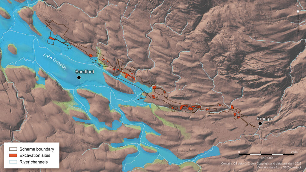
Image: shows the location and extent of Lake Ormside (now Sandford Mire) in relation to our excavation areas along the A66 route
Towards the end of the Ice Age, around 16,000 years ago, the climate began to warm, and glaciers across Cumbria started to melt and retreat. This process revealed the valleys we see today, including the Eden Valley, which runs east–west between the Lake District and the Pennines, forming an important corridor of human movement. As the ice melted, water flowed into these valleys, filling low-lying areas and creating wetlands, rivers and lakes that once dominated the landscape. This includes a key geoarchaeological feature called Lake Ormside.
Our Specialist Antony Dickson shares his knowledge:
“Lake Ormside extended from Appleby to Warcop. It drained when the River Eden cut through a new channel on the very west of the lake at an unknown date. It is likely that after its initial draining, the former lake basin still held an open body of water separated by islands and channels. The lake would have varied in size and depth as the climate shifted over time, influencing the position of the shoreline edge. Its basin now contains the modern-day Sandford Mire which has slowly infilled with organic layers since at least the Late Pleistocene around 12,000 years ago.”
Video: drone footage showing Cumbrian landscape and todays location of the modern-day Sandford Mire
These landscape features are clues that show archaeologists where people might have travelled, settled, or found resources long ago, helping us build a clearer story of the area’s prehistoric past.
Antony Says:
“We know from experience of working in similar landscapes that early prehistoric communities preferred having settlements near confluences of water courses, and locations where fine-grained sand and gravel deposits formed. Using geoarchaeology we have identified a stone tool site at the eastern end of Lake Ormside at Warcop where a probable in-situ Late Mesolithic (7000 to 4000 BC) encampment has been identified within buried layers. Further in-situ Mesolithic sites have also been recorded in former wetlands beyond the margins of the lake west of Brough. The location of these camps would have provided access to water and a wide range of plant and animal resources on the edges of wetland environments. .“
In-Situ: is used to refer to an object or archaeological feature that is found where it was originally placed or in its natural position.
Image: Later Upper Palaeolithic flint found on the edge of a prehistoric wetland along the A66
The geoarchaeological work that has been undertaken during the A66 excavations has enabled us to find evidence of these prehistoric settlements. Without it, these sites would have remained buried in the ground.
Antony explains:
“Geoarchaeology requires a lot of techniques to locate past landforms and features like Lake Ormside and the associated archaeology. We use LiDAR imagery together with geological surveys, mapping and satellite imagery to examine the present-day land surface across the project area. From this data we can use computer models to identify geoarchaeologically significant deposits, and in doing so better understand site locations that may be buried underneath layers of sediments.”
LiDAR: (light detector and ranging) technology uses lasers to measures distances of objects and the surface of Earth to create accurate images of the Earth’s surface and its characteristics such as landforms.
Image: archaeologist digging test pit into potentially significant deposit to locate archaeology
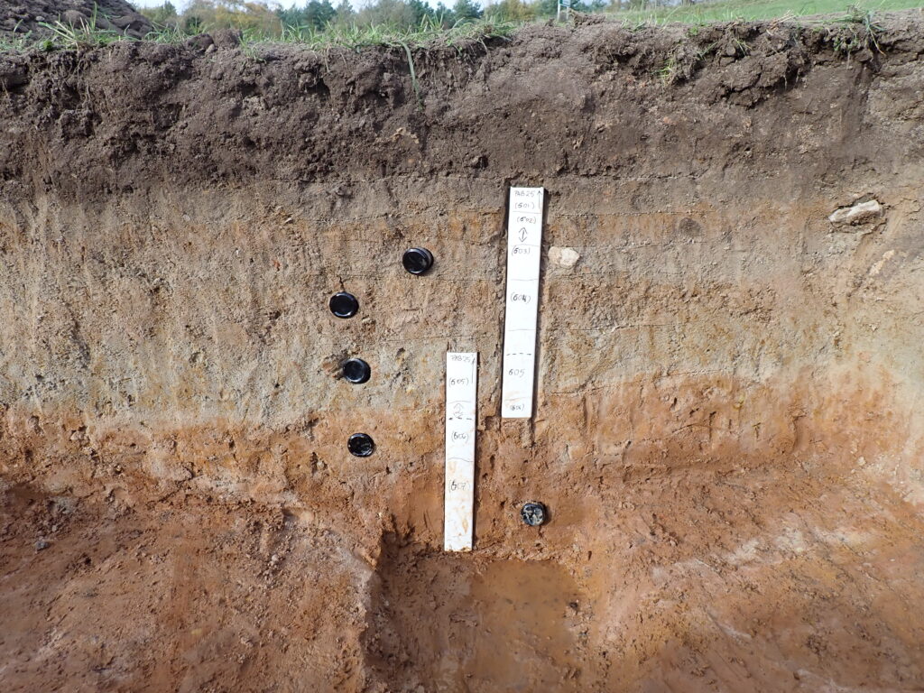
Image: OSL samples (black circles) and column samples in a section
To share how geoarchaeology is recorded on-site, our Project Officer Katie Sanderson and Supervisor Indigo Ridgewell are here to share their insights:
“When we find old surfaces, we can often find archaeological remains associated with them. This can include buried soils with charcoal from fire, peat, stone tool scatters, sequences of deposits which will tell us more information about the ancient landscape. To find these deposits we have been test pitting, sampling, and hand auguring – the latter method used to bring up small samples of sediment from deep in the ground. These have been carried out by the field team. We have also used mechanical excavators to put long slots through the deepest areas of built-up deposits.”
“The geoarchaeologists carry out specialist recording that requires detailed descriptions of the sediments. We also photograph, draw the sections, and take specialist samples such as column, and OSL (optically stimulated luminescence dating) samples for dating the layers of sediment that are of interest.“
OSL Samples: are optically stimulated luminescence samples used to date sediments found within geoarchaeological contexts
Image: field team recording section of deposits excavated by machine
Sediment: consists of mineral and/or organic material deposited by any process involving natural or human agencies
Image: archaeologist taking column samples of deposits
Through this work, our Oxford Cotswold Archaeology team are starting to untangle the complex history of the Cumbrian landscape. Scientific dating from the samples we collect on site will help us learn more about how people lived around the Lake Ormside wetlands in prehistoric times. By studying the different layers of soil, we can also build a rare picture of what the environment was like across all our A66 excavation areas. With further analysis, we hope to understand why people, from prehistory to more recent times, chose certain places to live, and how their choices shaped the landscape we see in Cumbria today.